Reflectivity in Doppler Radar
Reflectivity is one of the most commonly discussed aspects of Doppler radar, and it plays a key role in determining how much precipitation is falling in a given area. Essentially, reflectivity measures how much of the radar’s energy is reflected back to the radar after it strikes particles in the atmosphere, like raindrops, snowflakes, or hailstones. The more energy that’s reflected, the stronger the precipitation, which helps meteorologists assess storm intensity.
When a radar pulse travels through the atmosphere and hits precipitation particles, those particles reflect the pulse back to the radar. The amount of energy that returns to the radar depends on the size, shape, and density of the particles. Larger or denser particles, like hail or heavy rain, reflect more energy, resulting in a stronger radar return signal. Smaller particles, like light rain or snowflakes, reflect less energy.
Reflectivity data is color-coded to show the intensity of precipitation, with different colors representing different levels of reflectivity:
Meteorologists rely on this data to monitor storm strength and intensity. High reflectivity in red or purple areas may indicate severe storms, while lighter colors like green and yellow represent milder weather. Reflectivity data helps meteorologists determine if a storm is strengthening, weakening, or staying the same. It also helps in issuing flood or winter storm warnings when heavy rain or snow is expected.
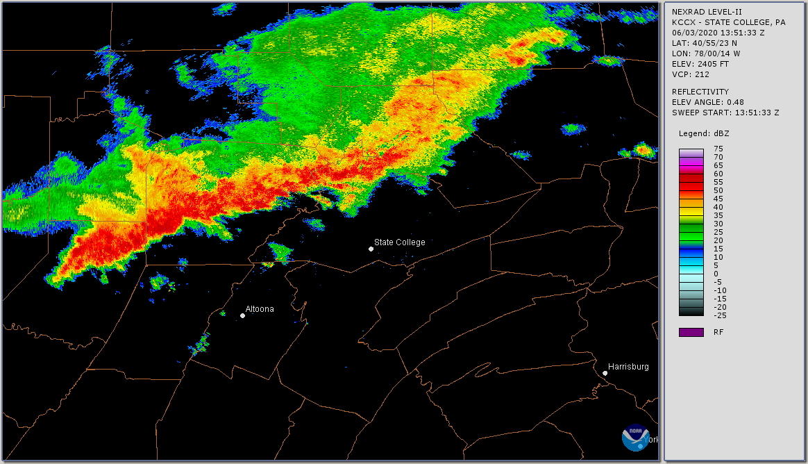
The radar image above shows a squall line of intense thunderstorms moving towards State College, Pennsylvania from the northwest, with some areas experiencing reflectivity levels exceeding 55 dBZ. dBZ stands for decibels of Z, a measure of radar reflectivity that indicates the strength of the return signal from precipitation particles. The higher the dBZ value, the stronger the reflection, which usually corresponds to more intense precipitation. For instance, values above 50 dBZ are typically associated with heavy rainfall, while values in the 60–70 dBZ range are often linked to severe thunderstorms with very heavy rainfall or hail. However, inferring specific rainfall rates from radar can be tricky because reflectivity can vary based on the size and type of raindrops, with larger drops reflecting more energy than smaller ones.